Mapping
Zoom
Netherlands
Use EasyMapMaker to map excel or other spreadsheet data onto a google map. EasyMapMaker takes the work out of manually plotting multiple locations on a map. The first step is to copy (or drag & drop) your spreadsheet data including the column headers into the table by clicking on the table to reveal a text box. The data must include some location information, either an address or latitude/longitude coordinates.
Set Address Options and Select Features
Set the options for your map. Be sure to set location information. Location information can consist of many combinations of the address (street, city, state, zip) as well as the latitude and longitude (set explicitly in separate columns). The whole location can be in one column and be set as the address, or it can be in multiple columns. Set other options if the data contains them. Use Advanced Options to add filters, add a left direction panel with a radius filter, hide certain data, upload a custom logo, or use custom markers (pins).
Process addresses to Generate Map
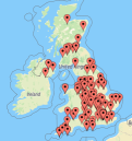
Click on Make Map and wait for address location data to be translated into latitude and longitude so it can be placed on the map. Once the data is on the map, the pins can be moved or removed. Once the map looks good, save it. An email will be sent for your records to access the map in the future. After the map is saved, the map url will be provided. This url can be changed to something easier to remember. You can share the map, embed the map on a webpage, or print the map.